
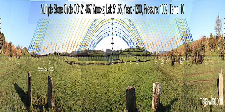
 This is the more southerly of two multiple stone circles in the townland of Knocks and is about 3km south of Ballingurteen, West Cork; to the west of the R599.
Six stones remain, one of which is a central monolith. Originally the circle may have had nine or eleven stones as well as the central monolith.
This is the more southerly of two multiple stone circles in the townland of Knocks and is about 3km south of Ballingurteen, West Cork; to the west of the R599.
Six stones remain, one of which is a central monolith. Originally the circle may have had nine or eleven stones as well as the central monolith.
South is in a dip [Pic].
![[Pic].](KnocksS-S.jpg)
North is close to the very local highest point and indicated by a stone [Pic].
![[Pic].](KnocksS-N.jpg)
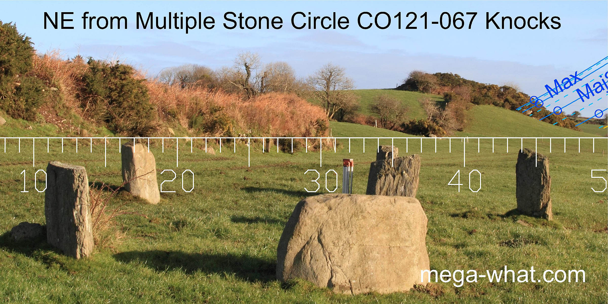
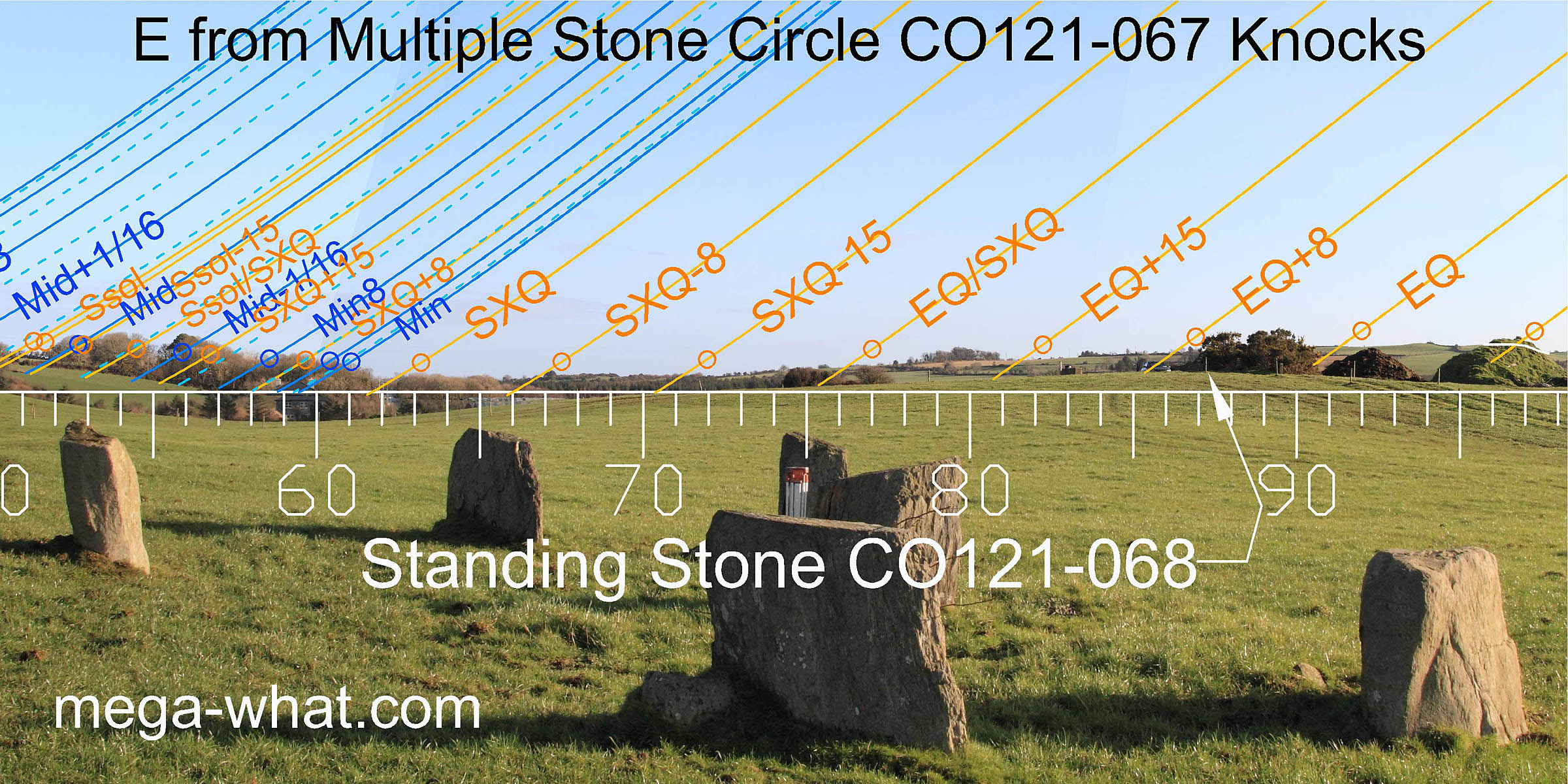
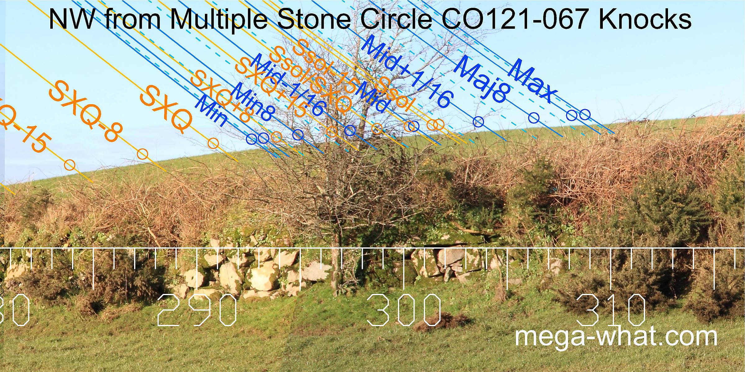
 To the north-east, the circle's axis is beyond the lunar maximum but the lunisticeLunistices are the most northerly and southerly moons of the month. The lunar equivalent of solstices - more.
range runs up from the bottom of the slope and the significant terminal marker is for the major eighth.
To the north-east, the circle's axis is beyond the lunar maximum but the lunisticeLunistices are the most northerly and southerly moons of the month. The lunar equivalent of solstices - more.
range runs up from the bottom of the slope and the significant terminal marker is for the major eighth.
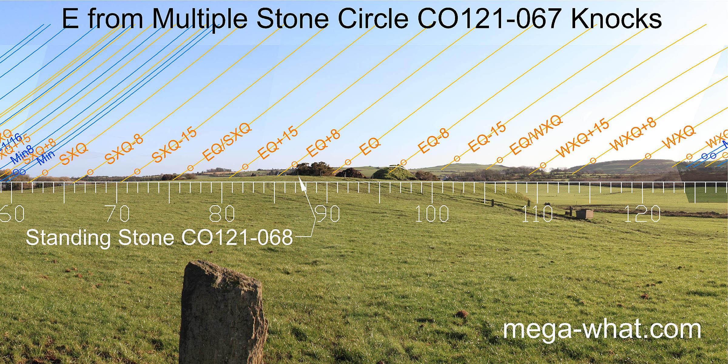 An outlying Standing Stone (CO121-068) is 90m away and may be brought to the horizon by crouching down. Its position gives better views to the north but has not been surveyed.
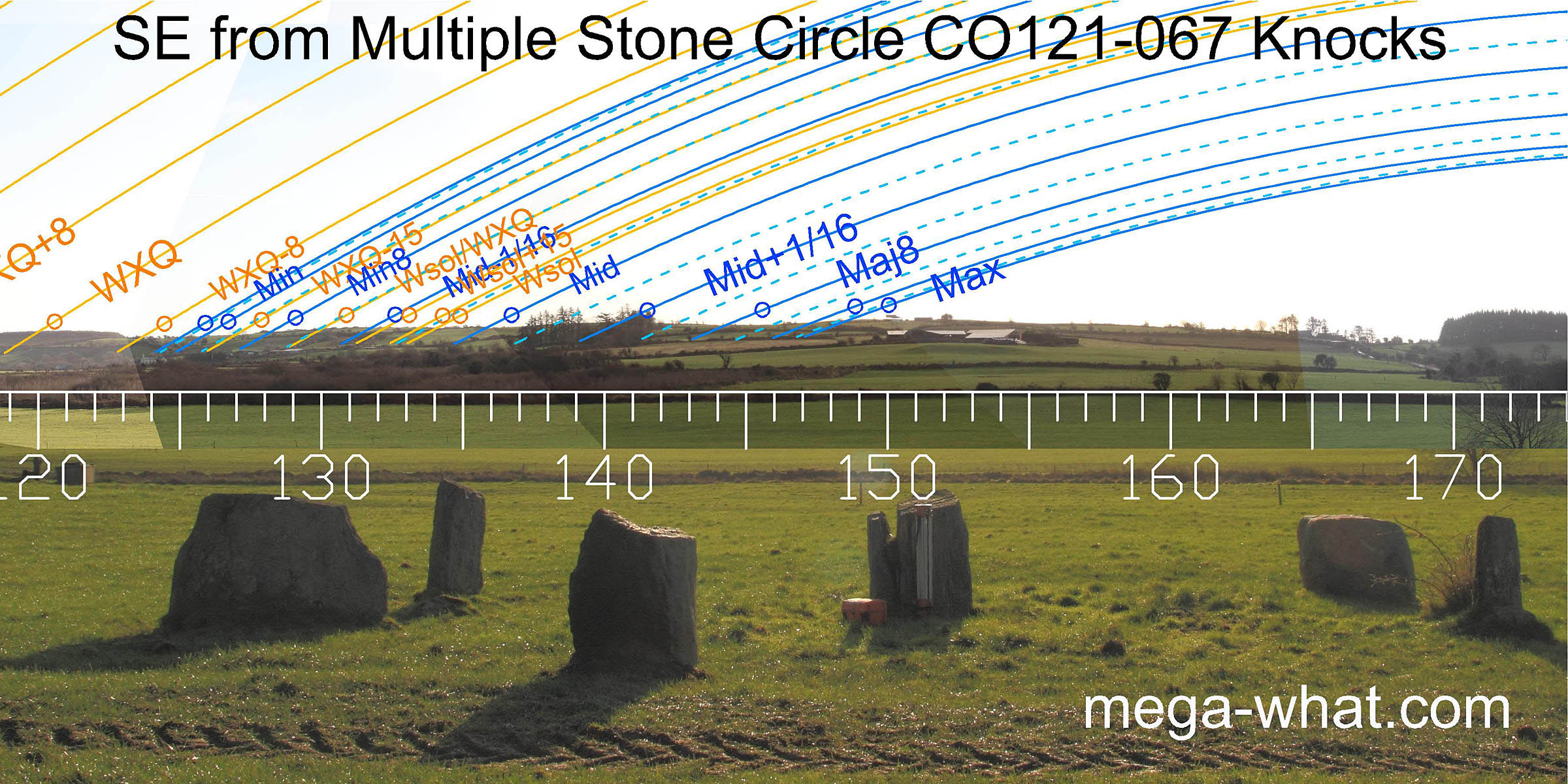 South-east is a long ridge, separated into broad tops by slight dips which are all significant markers. Lunar major standstillLunistice positions vary cyclically over an 18.6 year period but are fairly static for more than a year at either end of the range
moonrise is on a hilltop and indicated by the central monolith.
South-east is a long ridge, separated into broad tops by slight dips which are all significant markers. Lunar major standstillLunistice positions vary cyclically over an 18.6 year period but are fairly static for more than a year at either end of the range
moonrise is on a hilltop and indicated by the central monolith.
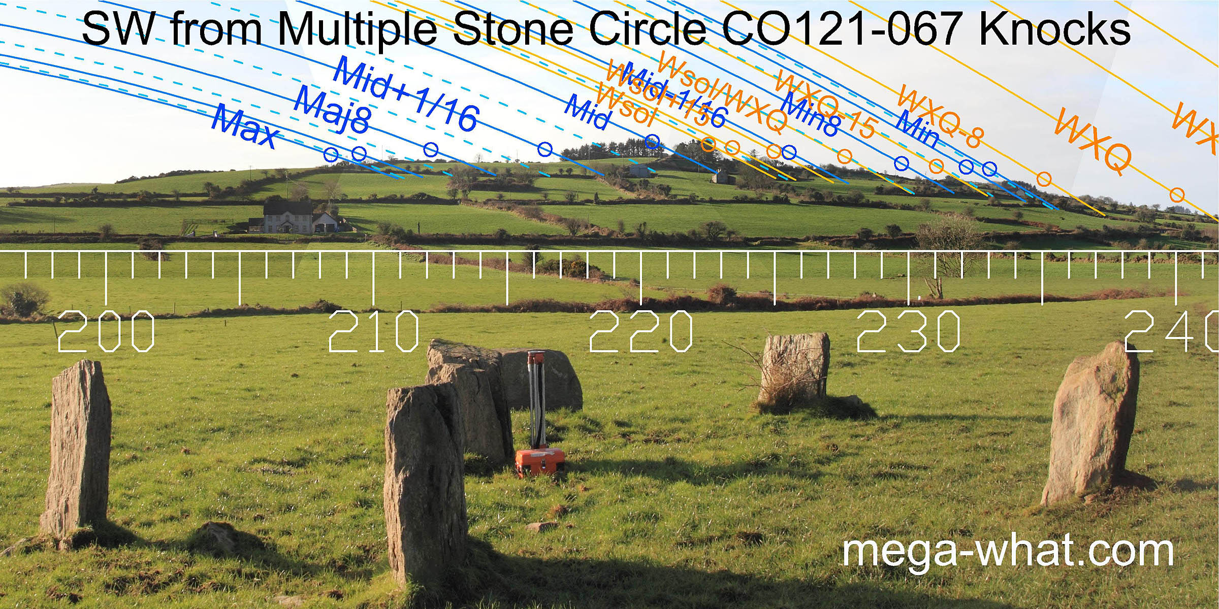 The prominent axial hilltop has winter solstice and the lunar midpoint on it but the axial stone indicates the east side of the hill.
A step above it marks a lunar sixteenth and another step marks major standstillLunistice positions vary cyclically over an 18.6 year period but are fairly static for more than a year at either end of the range
moonset. The minor end of the lunisticeLunistices are the most northerly and southerly moons of the month. The lunar equivalent of solstices - more.
range occurs at a bumpy part of the hill's western slope
which also provides half and quarter month brackets for the winter cross-quarter which itself occurs on smooth hillslope.
The prominent axial hilltop has winter solstice and the lunar midpoint on it but the axial stone indicates the east side of the hill.
A step above it marks a lunar sixteenth and another step marks major standstillLunistice positions vary cyclically over an 18.6 year period but are fairly static for more than a year at either end of the range
moonset. The minor end of the lunisticeLunistices are the most northerly and southerly moons of the month. The lunar equivalent of solstices - more.
range occurs at a bumpy part of the hill's western slope
which also provides half and quarter month brackets for the winter cross-quarter which itself occurs on smooth hillslope.
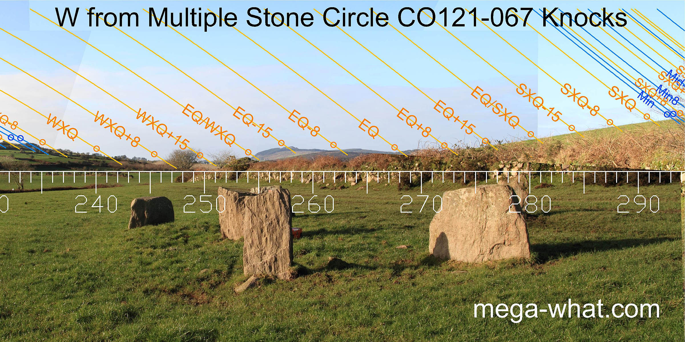 A wide dip between the axial hill and Carrig Fadda gives quarter and half-month brackets to the cross-quarter
(Carrigagrenane Stone Circle is just out of sight here).
The basal step is half-way to the cross-quarter and the top is a half-month south of the equinox. A prominent equinoctial notch is just south of the local intersect.
A wide dip between the axial hill and Carrig Fadda gives quarter and half-month brackets to the cross-quarter
(Carrigagrenane Stone Circle is just out of sight here).
The basal step is half-way to the cross-quarter and the top is a half-month south of the equinox. A prominent equinoctial notch is just south of the local intersect.
 North-western and northern horizons are extremely local. North is close to the highest point and indicated by a stone [Pic].
- The other Stone Circle in this townland is about 1.4km north of this one and en route to it is an unsurveyed probable Stone Row that has been classified as a Stone Pair (CO121-066).
- Three km to the east is Ahagilla Stone Circle and half-way there is the Stone Row at Knockatlowig.
- Yet another Stone Circle is 3.9km to the west at Maulatanvally and half-way there are the Five Stone Circle and Stone Pair at Glanbrack.
References
- Archaeological Survey of Ireland, record details. www.archaeology.ie/archaeological-survey-ireland
- BARBER, JOHN 1973 The Orientation of the recumbent-stone circles of the South-West of Ireland. Journal of the Kerry Historical and Archaeological Society 6:26-39, no.C16.
- Ó'NUALLÁIN, SEÁN 1984 A Survey of Stone Circles in Cork and Kerry. Proceedings of the Royal Irish Academy 84c:1-77, p21, No.29.
- POWER, D. et al. 1992 Archaeological Inventory of County Cork, Volume 1: West Cork. Dublin: Stationary Office. p22, no.58 & p61, no.428.
- RUGGLES, C.L.N. 1999 Astronomy in Prehistoric Britain and Ireland. Newhaven & London: Yale University Press. No.ASC43.
- RUGGLES, C.L.N. & PRENDERGAST, F. 1996 A New Archaeoastronomical Investigation of the Irish Axial-Stone Circles. Proceedings of the 2nd SEAC [European Society for Astronomy in Culture] Conference, Bochum, 1994. Bochum: Astronomisches Institut der Ruhr-Universität. pp5-13.